 Abandoned
Overview
Iron for three wars

Long Pond Ironworks lies on the Wanaque River beside CR 511 in Hewitt, a section of West Milford. Peter Hasenclever, a German ironmaster, founded it in 1765 or 1766, depending on the source, and brought some 500 ironworkers and their families from Germany for it and his other New Jersey works. A dam at Long Pond, today's Greenwood Lake, powered the furnace blast and a forge.
The works made iron for the Continental Army, the War of 1812 and the Union Army. Peter Cooper and Abram S. Hewitt's firm took it over in 1853 and added two furnaces and new waterwheels in the 1860s. Iron makers were moving to anthracite furnaces near the Pennsylvania coal fields, and in 1882 the last fires here were blown out.
The village of Hewitt held on with a church, a store and post office, schools and a sawmill, then emptied in the 1930s. The Ringwood Company gave the land to the state in 1957, and it became a state park in 1987. Wikipedia gives the park 145 acres. The Friends of Long Pond Ironworks give the historic district 175 acres on their home page and 170 on their history page, as NJ Skylands does.
Video
A late-summer walk through Hewitt
Two hikers walk the historic district in late summer, with a sign by the road for the Friends' Victorian Day. They start at the old store museum and its trail kiosk, pass a white house whose back has fallen in under a blue tarp, the red houses, the barn and the stone double house, then the brick and stone ruins and the two waterwheels in their shelters, seen from outside. They cross a footbridge and follow the loop trail through the woods to a small waterfall. The narration is the creators' own. It dates the works to the early 1700s; the Friends give 1765 and Wikipedia 1766.
 Play “We found an abandoned Iron Village in New Jersey....!” from YouTube
Timeline
More than a century of iron

- German ironmaster Peter Hasenclever founds the works on the Wanaque River. Wikipedia and NJ Skylands say he brought 500 ironworkers and their families from Germany; the Friends say more than 500 European workers and families, for his works at Ringwood, Long Pond and Charlottenburg. The Friends of Long Pond Ironworks give 1765; Wikipedia and NJ Skylands give 1766.
- A dam at Long Pond, now Greenwood Lake, gives water power for a blast furnace and a large forge.
- Ironmaster Robert Erskine supplies iron to the Continental Army. He serves as Washington's chief mapmaker.
- Martin J. Ryerson buys the ironworks.
- Peter Cooper, Edward Cooper and Abram S. Hewitt take over the properties and run them as part of the Trenton Iron Company.
- For the Civil War, two new blast furnaces, new waterwheels and workers' housing are built. The iron suits the Union Army's guns.
- The last fires are blown out. NJ Skylands says Hewitt moved iron making to a site near the Pennsylvania coal fields; Wikipedia blames newer works in Pittsburgh.
- Hewitt residents build a new school and church; a new sawmill follows in 1913.
- Local industry fails in the Depression and residents move away.
- The Ringwood Company gives the property to the State of New Jersey. The same year vandals set fire to the two waterwheels, by NJ Skylands' account; Wikipedia says one.
- Listed on the New Jersey Register on September 4, 1973 and the National Register on January 11, 1974.
- The site is dedicated as a state park. The Monksville Reservoir, which covers the old village of Monksville, lies beside it.
- The Friends of Long Pond Ironworks and the state park run a visitor center and museum on weekends. One burned wheel is kept as found; the other has been rebuilt.
What's left
What you'll see


NJ Skylands counted twelve buildings and some 70 ruins in 2002, three furnaces among them. The two Hewitt-era furnaces still show a blowing arch. The wheels produced about 200 horsepower. After the 1957 fire the Friends kept one charred wheel on its original iron axle and rebuilt the other in wood, 25 feet across, on a cast-iron axle. Both now stand under a shelter. A stone double house from the late 1700s may be the oldest building in the district. The village store holds the museum.
Trail maps for a self-guided walk are at the visitor center and the parking lot kiosk. The flooded mine hole is taped off and signed closed. On the 1891 USGS sheet below, the Furnace and Hewitt sit side by side on the river below Greenwood Lake, with Peters Mine and Cannon Mine to the east. The 1954 sheet shows Hewitt strung along the road and the river before the reservoir; today's topo has the Monksville Reservoir right beside it.
- Blast furnace ruins (three furnaces)
- Two waterwheels, one burned and one rebuilt
- Stone double house (late 1700s)
- Village store, now the museum
- Church and schoolhouses
- Workers' and managers' houses
- Slag, charcoal and ice house ruins


Historic maps
Long Pond Ironworks on USGS maps, 1891–1954
Crops from the USGS Historical Topographic Map Collection, centered on the townsite. Each sheet shows what surveyors mapped that year; compare them with today's topo and aerial on this page.

Day trip
Plan a day trip to Long Pond Ironworks from Ringwood
Take it with you
Day trip itinerary
The essentials, the sample day with boxes to tick, what to photograph and the coordinates, on two printable pages. Handy where there's no signal.
Download the PDF (636 KB)Long Pond is a short drive from Ringwood and an easy half day. The trails are open every day; come on a weekend afternoon before mid-November for the museum.
A sample day
- Drive CR 511 from Ringwood, about 11 minutes. Pick up a trail map at the kiosk.
- Walk the historic district: the furnace ruins, the two waterwheels and the stone double house.
- Visit the museum in the village store.
- Look out over the Monksville Reservoir from its shore.
What to photograph and film
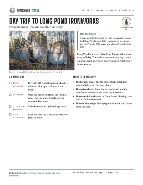
- The furnace ruins. The tall stone stacks catch low autumn light, as in the hero photo.
- The waterwheels. Shoot the burned wheel and the rebuilt one side by side to show the difference.
- The stone double house. Its front faces a clearing; step back to fit the whole wall.
- The mine hole sign. Photograph it from the trail. Don't cross the tape.
Map & directions
Getting there
Ringwood is the closest town, about 11 minutes away by Skylands Road and the Greenwood Lake Turnpike (CR 511). From New York City the route runs through the Holland Tunnel and north on NJ 17, NJ 208 and I-287, a little over an hour.


Base map: USGS The National Map (public domain). Routes: OSRM on © OpenStreetMap contributors data (ODbL), computed October 2026. Times assume dry roads.
- From Ringwood, turn right on Glen Road, left on Cupsaw Drive and left on Mohawk Trail.0.4 mi
- Turn right on Skylands Road.0.8 mi
- Turn sharp right on the Greenwood Lake Turnpike (CR 511) and follow it to the ironworks.4.1 mi
- From Park Row, follow Church and Hudson Streets to the Holland Tunnel approach.1.2 mi
- Take the Holland Tunnel (I-78) and 14th Street in Jersey City.2.2 mi
- Follow NJ 139 to the ramp for Tonnelle Avenue.1.2 mi
- Take Tonnelle Avenue (US 1/9) north.2.6 mi
- Follow NJ 3 west.4.3 mi
- Take the ramps to NJ 17 and follow it north.8.5 mi
- Take the ramps to NJ 4, which becomes NJ 208.11.5 mi
- Merge onto I-287 and leave at exit 57.1.4 mi
- Follow Skyline Drive north.4.8 mi
- Turn right on the Greenwood Lake Turnpike (CR 511) to the ironworks.4.9 mi
Road and safety notes
- The site is at 1334 Greenwood Lake Turnpike (CR 511), Hewitt.
- The flooded mine hole is closed. A sign photographed in October 2025 bans swimming and other unauthorized activities there.
- Monksville Reservoir's north, south and Beech Road launches are open 24 hours. In May 2026 the state warned that the reservoir was being lowered about 6 feet or more to supply the Wanaque Reservoir; watch for stumps when launching (state park page, archived May 14, 2026).
- The state park charges no entrance fee and has no trash cans: carry out what you bring.
Photos
Long Pond Ironworks in photos
Visitor reports
Been to Long Pond Ironworks?
Been there lately? Tell the next visitor what you found: whether you could get in, the state of the road and what's still standing. Photos are welcome. We read every report before it appears here.
Other mining and oil
More lead, iron, mercury and oil ghost towns
The nearest in New Jersey.

 Guide
Allaire Village
40.16, -74.13Monmouth County, New Jersey
James P. Allaire's Howell Works smelted bog iron here for his New York steam engine shops, then went cold in the 1840s. Thirteen of its buildings…
 Guide
Atsion
39.74, -74.73Burlington County, New Jersey
An ironworks village in the Pine Barrens that failed, revived under the Richards family, and emptied again. Its 1826 mansion stands beside Atsion…
Nearby
Other sites near Long Pond Ironworks
Straight-line distance from the townsite to other mapped sites in our New Jersey index.
- Monksville1.3 mi S · Passaic
- Hibernia16.6 mi SW · Morris
- Waterloo Village28.0 mi SW · Sussex
- Walpack Center29.7 mi W · Sussex
- Feltville32.0 mi S · Union
- Millbrook34.4 mi W · Warren
- Raritan Landing44.2 mi S · Middlesex
- Foul Rift47.3 mi SW · Warren
Sources
Sources and credits
- ghosttowns.com, "Long Pond Ironworks": fact sheet fields (county, road, remains, best time), Hasenclever and the 500 workers, the 1860s furnaces and the 1882 end with the move to anthracite.
- Wikipedia, "Long Pond Ironworks State Park", retrieved October 2026: 1766 founding, the dam at Long Pond, iron for three wars, the village of Hewitt and its buildings, the store museum, 145 acres, Monksville Reservoir, one wheel burned in 1957, the 1882 end blamed on Pittsburgh, register listings (September 4, 1973 and January 11, 1974), coordinates.
- Friends of Long Pond Ironworks: home page, "Visit", "Museum & Visitor Center" and "History", read October 29, 2026: museum and trail hours, the 2026 season end, address, phone, trail maps, the visitor center's restrooms, the 175-acre historic district (home page) and 170 acres (history page); 1765 founding, more than 500 workers for three works, Erskine, Ryerson 1807, Cooper and Hewitt 1853, Civil War furnaces, 1882, Hewitt's school, church and sawmill, the 1930s, the 1957 gift and the 1987 state park.
- Mary Jasch, "Long Pond Ironworks", NJ Skylands (Spring 2002): Hasenclever's 1766 works two miles below Long Pond, Hewitt's move to the coal fields in 1882, twelve buildings and some 70 ruins, the blowing arches, the 1957 fire and the two wheels, the stone double house.
- Wikimedia Commons photographs of October 19, 2025 (LandyFeeled): the mine hole closure sign, the waterwheels and the stone double house as they stood then.
- NJ State Park Service, "Long Pond Ironworks State Park", archived copy of May 14, 2026 (the live page is behind a bot wall): no entrance fee, the park office phone, no swimming in the park, no trash cans, partial accessibility, the Monksville Reservoir launches open 24 hours and the advisory that the reservoir was being lowered about 6 feet or more.
- Roadlife247, "We found an abandoned Iron Village in New Jersey....!," YouTube, posted November 28, 2025: the video on this page; the store, houses, ruins, waterwheels and loop trail in late summer.
- Elevation: USGS 3D Elevation Program point query. Routes: OSRM on OpenStreetMap data, October 2026.
Photo and map credits
- The furnace ruins, November 2017: Ccrabb1948, Wikimedia Commons, CC BY-SA 4.0
- The Civil War-era furnace ruins, July 2008: KForce at en.wikipedia, Wikimedia Commons, CC BY-SA 3.0
- The village store and visitor buildings, July 2008: KForce at en.wikipedia, Wikimedia Commons, CC BY-SA 3.0
- The stone double house, October 2025: LandyFeeled, Wikimedia Commons, CC BY-SA 4.0
- The burned waterwheel's iron hub and charred spokes, October 2025: LandyFeeled, Wikimedia Commons, CC BY-SA 4.0
- The burned wheel under its shelter, October 2025: LandyFeeled, Wikimedia Commons, CC BY-SA 4.0
- The rebuilt wooden wheel, October 2025: LandyFeeled, Wikimedia Commons, CC BY-SA 4.0
- The rebuilt wheel's axle and gearing, October 2025: LandyFeeled, Wikimedia Commons, CC BY-SA 4.0
- A trail through the historic district in autumn, October 2025: LandyFeeled, Wikimedia Commons, CC BY-SA 4.0
- Sign at the mine hole: closed due to dangerous conditions, swimming prohibited, October 2025: LandyFeeled, Wikimedia Commons, CC BY-SA 4.0
- The Furnace and Hewitt on the 1891 USGS Greenwood Lake sheet: U.S. Geological Survey, USGS catalog, Public domain
- Hewitt on the 1954 USGS sheet, before the reservoir: U.S. Geological Survey, USGS catalog, Public domain
- Area base map, topo and aerial imagery: USGS The National Map (public domain).
- Historic maps: USGS Historical Topographic Map Collection (public domain): Greenwood Lake 1891, 1:62,500; Greenwood Lake 1910, 1:62,500; Greenwood Lake 1943, 1:31,680; Greenwood Lake 1954, 1:24,000.